ARFF Daily News
Published on:
Wednesday the 15th of January, 2025
FAA investigating small plane crash in Conway area; no injuries reported
By Makayla Evans, Ashley Listrom and WMBF News Staff
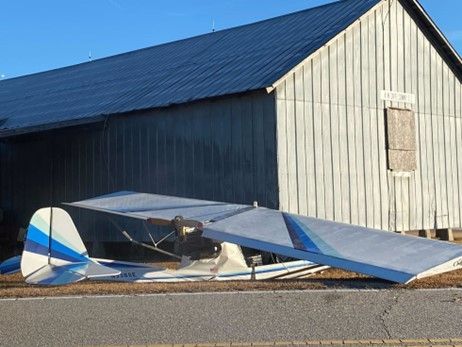
HORRY COUNTY, SC (WMBF) - The FAA is investigating after a small plane crashed into a shed near Conway.
Horry County Fire Rescue responded just before 7 a.m. to West Brownway Circle off Cates Bay Highway for the Tuesday plane crash.
HCFR said the plane hit a shed that sustained minor damage. The shed’s owner told WMBF News there’s a hole in the shed from where the plane hit.
WMBF News also learned that the crash damaged the plane as well. The FAA said the plane is a Quad City Challenger II Ultralight plane.
Luckily, the two people on the plane are okay, according to HCFR.
Leonard Cannon, a neighbor who has lived in the area for 90 years, said he heard the sirens but didn’t expect it to be a small plane crash.
“All we’ve ever heard of was maybe a car accident or something, but not no airplane falling,” Cannon said. “Nobody would have believed it.”
The shed owner, who did not talk to WMBF News on camera, claimed the plane ran out of fuel trying to make it to the Conway–Horry County Airport. The shed owner said the pilot tried to land in a field across the street but didn’t see the power line and had to either go under or over it and hit the shed in the process.
The FAA said it’s expected to release its preliminary report into the crash on Wednesday, which could give more insight into what caused the crash.
The shed is used to store the owner’s furniture, and he said it would take about a week to fix the damage and cost around $5,000 to $10,000.
https://www.wmbfnews.com/2025/01/14/small-aircraft-crashes-into-shed-near-conway-hcfr-says/
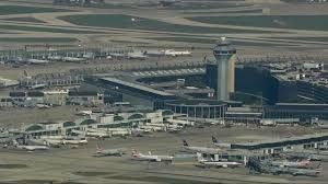
United plane hits coyote during takeoff at Chicago O'Hare Airport; FAA investigating
ByABC7 Chicago Digital Team
CHICAGO (WLS) -- A plane hit a coyote during takeoff at Chicago O'Hare Airport on Sunday and diverted back to the airport after declaring an emergency, officials said.
According to the airline, United flight 1727 safely returned to O'Hare around 10:45 a.m. "to examine the aircraft after its landing gear struck a coyote during takeoff."
The Boeing 737 MAX 9, carrying 167 passengers and six crew members, was scheduled to fly to Phoenix and another plane took passengers to their destination later that afternoon.
The pilot declared an emergency and could be heard on air traffic control audio saying, "During the rotation we hit a pretty big animal and we're suspecting of causing damage the nose and landing gear."
The Federal Aviation Administration is investigating.
https://abc7chicago.com/post/coyote-chicago-plane-hits-ohare-airport-during-takeoff-united-flight-1727-returns-safely/15799861/
NTSB Prelim: American Eurocopter LLC AS350B3
The Helicopter Came To Rest On Its Left Side In A Field Of Dry Brush
Location: Potrero, CA Accident Number: WPR25FA062
Date & Time: December 16, 2024, 10:30 Local Registration: N617GC
Aircraft: American Eurocopter LLC AS350B3 Injuries: 1 Fatal
Flight Conducted Under: Public aircraft
On December 16, 2024, about 1030 Pacific standard time, an Airbus A350 B3 helicopter, N617GC, was substantially damaged when it was involved in an accident near Potrero, California. The pilot was fatally injured. The helicopter was operated as a public use flight.
According to a representative of Customs and Border Protection (CBP), the helicopter was scheduled for a routine aerial support mission. Automatic Dependent Surveillance-Broadcast (ADS-B) data from the Federal Aviation Administration showed that the helicopter departed Brown Field Municipal Airport, San Diego, California about 0856 on a westerly heading and subsequently began a climbing right turn to the north. At 1006:54, approximately 1,000 ft mean sea level (msl), the helicopter turned east and continued to climb as it gradually transitioned to a northeasterly heading. At 0933:59 the helicopter leveled off at approximately 5,800 ft msl and then turned southeast for approximately 7 minutes as it descended. At 0950:38, the helicopter reached 4,650 ft msl, and began another climb that would return it to an altitude of 5,800 ft msl over the next 14 minutes.
At 1007:52, the helicopter made an extended left hand 360° turn, descended to about 4,600 ft msl and climbed again to about 5,600 ft msl. At 1021:58 the helicopter turned to the southwest and leveled off 4 minutes later at 4,300 ft msl. At 1029:26, in the next 49 seconds the helicopter made two S-turns as it descended from 4,200 ft to 3,100 ft msl. According to the Air Force Rescue Coordination Center, the emergency locator transmitter sent its first detection at 1030:34.
The helicopter came to rest on its left side in a field of dry brush on a magnetic heading of 309° at a field elevation of about 2,450 ft mean sea level. Three distinct ground scars were observed near the tailboom. A 4 foot long by 2 foot wide ground signature was located next to the outboard end of one of the main rotor blades. Another main rotor blade was resting within a second ground scar located approximately 1 foot forward of the first ground scar. A third ground scar was located about 6 inches away from the left horizontal stabilizer. All three main rotor blades remained attached to the rotor hub and were fractured at various points with broom strawing and fragmentation.
The helicopter wreckage was retained for further examination.
FMI: www.ntsb.gov
NTSB Final Report: Kitfox IV 1200 SPDST
Pilot’s Failure To Maintain Aircraft Control, Which Resulted In An Aerodynamic Stall And Impact With Terrain
Location: Cleburne, Texas Accident Number: CEN24LA363
Date & Time: September 20, 2024, 19:30 Local Registration: N16KR
Aircraft: Kitfox IV 1200 SPDST Aircraft Damage: Substantial
Defining Event: Aerodynamic stall/spin Injuries: 2 Minor
Flight Conducted Under: Part 91: General aviation - Personal
Analysis: The pilot reported that as he initiated the round out for landing, the airspeed rapidly decreased. He executed a go-around by increasing power and pitching the airplane to climb out. After about two seconds the right wing dipped, and the airplane stalled. The airplane impacted terrain which resulted substantial damage to the left wing and fuselage. The airplane came to rest upright on a fence.
The pilot reported that there were no preimpact mechanical failures or malfunctions that would have precluded normal operations.
Probable Cause and Findings:
The National Transportation Safety Board determines the probable cause(s) of this accident to be --
The pilot’s failure to maintain aircraft control, which resulted in an aerodynamic stall and impact with terrain.
FMI: www.ntsb.gov

Today in History
2 Years ago today: On 15 January 2023 Yeti Airlines flight 691, an ATR 72-500, crashed while on final approach to runway 12 at Pokhara International Airport, Nepal. The aircraft crashed on the bank of Seti River and partially ended up in a deep gorge, killing all 72 on board.
Date: Sunday 15 January 2023
Time: 10:57
Type: ATR 72-500 (72-212A)
Owner/operator: Yeti Airlines
Registration: 9N-ANC
MSN: 754
Year of manufacture: 2007
Engine model: P&W Canada PW127
Fatalities: Fatalities: 72 / Occupants: 72
Other fatalities: 0
Aircraft damage: Destroyed, written off
Category: Accident
Location: 2 km WNW of Pokhara International Airport (VNPR) - Nepal
Phase: Approach
Nature: Passenger - Scheduled
Departure airport: Kathmandu-Tribhuvan Airport (KTM/VNKT)
Destination airport: Pokhara International Airport (VNPR)
Investigating agency: Nepal AAIC
Confidence Rating: Accident investigation report completed and information captured
Narrative:
Yeti Airlines flight 691, an ATR 72-500, crashed while on final approach to runway 12 at Pokhara International Airport, Nepal. The aircraft crashed on the bank of Seti River and partially ended up in a deep gorge, killing all 72 on board.
The flight was operated by two captains, one captain was in the process of obtaining aerodrome familiarization for operating into Pokhara and the other captain being the instructor pilot. The captain being familiarized, who was occupying the left hand seat, was the Pilot Flying (PF) and the instructor pilot, occupying the right hand seat, was the Pilot Monitoring (PM).
They had operated two sectors between Kathmandu and Pokhara earlier in the morning.
The take-off, climb, cruise and descent to Pokhara was normal. During the first contact with Pokhara tower the Air Traffic Controller (ATC) assigned the runway 30 to land. At a later time, the flight crew requested and received clearance from ATC to land on runway 12.
At 10:51:36, the aircraft descended from 6,500 feet and joined the downwind track for runway 12 to the north of the runway.
The aircraft was visually identified by ATC during the approach. At 10:56:12, the pilots extended the flaps to the 15 degrees position and selected the landing gears lever to the down position. The take-off (TO) setting was selected on power management panel.
At 10:56:27, the PF disengaged the Autopilot System (AP) at an altitude of 721 feet Above Ground Level (AGL). The PF then called for "FLAPS 30" at 10:56:32, and the PM replied, "Flaps 30 and descending". The flight data recorder (FDR) data did not record any flap movement at that time.
Instead, the propeller rotation speed (Np) of both engines decreased simultaneously to less than 25% and the torque (Tq) started decreasing to 0%, which is consistent with both propellers going into the feathered condition. This was followed by a single Master Caution chime.
The flight crew then carried out the "Before Landing Checklist" before starting the left turn onto the base leg. During that time, the power lever angle increased from 41% to 44%. At the point, Np of both propellers were recorded as Non-Computed Data (NCD) in the FDR and the torque (Tq) of both engines were at 0%.
At 10:56:50 when the radio altitude callout for five hundred feet was annunciated, another 'click' sound was heard, likely the crew had inhibited the master caution light.
The aircraft reached a maximum bank angle of 30 degrees at this altitude. The yaw damper disconnected four seconds later. The PF consulted the PM on whether to continue the left turn and the PM replied to continue the turn. Subsequently, the PF asked the PM on whether to continue descend and the PM responded it was not necessary and instructed to apply a little power. At 10:56:54, another click was heard, followed by the flaps surface movement to the 30 degrees position.
When ATC gave the clearance for landing at 10:57:07, the PF mentioned twice that there was no power coming from the engines. At 10:57:11, the power levers were advanced first to 62 degrees then to the maximum power position.
It was followed by a 'click' sound at 10:57:16. One second afterwards, the aircraft was at the initiation of its last turn at 368 feet AGL, the high-pressure turbine speed (Nh) of both engines increased from 73% to 77%.
At 10:57:18 the PF handed over control of the aircraft to the PM and the PM (who was previously the PF) repeated again that there was no power from the engines. At 10:57:24 when the aircraft was at 311 feet AGL, the stick shaker was activated.
At 10:57:26, a second sequence of stick shaker warning was activated when the aircraft banked towards the left abruptly. Thereafter, the radio altitude alert for two hundred feet was annunciated, and the cricket sound and stick shaker ceased. At 10:57:32, the aircraft impacted the ground.
The Pokhara International Airport was opened on January 1, 2023 and is located to the east-southeast of the old Pokhara Airport.
The most probable cause of the accident is determined to be the inadvertent movement of both condition levers to the feathered position in flight, which resulted in feathering of both propellers and subsequent loss of thrust, leading to an aerodynamic stall and collision with terrain.
The contributing factors to the accident are:
1 High workload due to operating into a new airport with surrounding terrain and the crew missing the associated flight deck and engine indications that both propellers had been feathered.
2 Human factor issues such as high workload and stress that appears to have resulted in the misidentification and selection of the propellers to the feathered position.
3 The proximity of terrain requiring a tight circuit to land on runway 12. This tight circuit was not the usual visual circuit pattern and contributed to the high workload. This tight pattern also meant that the approach did not meet the stabilised visual approach criteria.
4 Use of visual approach circuit for RWY 12 without any evaluation, validation and resolution of its threats which were highlighted by the SRM team of CAAN and advices proposed in flight procedures design report conducted by the consultant and without the development and approval of the chart by the operator and regulator respectively.
5 Lack of appropriate technical and skill based training (including simulator) to the crew and proper classroom briefings (for that flight) for the safe operation of flight at new airport for visual approach to runway 12.
6 Non-compliance with SOPs, ineffective CRM and lack of sterile cockpit discipline.

Mailing Address
Subscribe to our newsletter
Contact Us
We will get back to you as soon as possible.
Please try again later.