ARFF Daily News
Published on:
Friday the 7th of February, 2025
Pilot uninjured after landing without gear at Centennial Airport
by: Brooke Williams
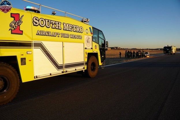
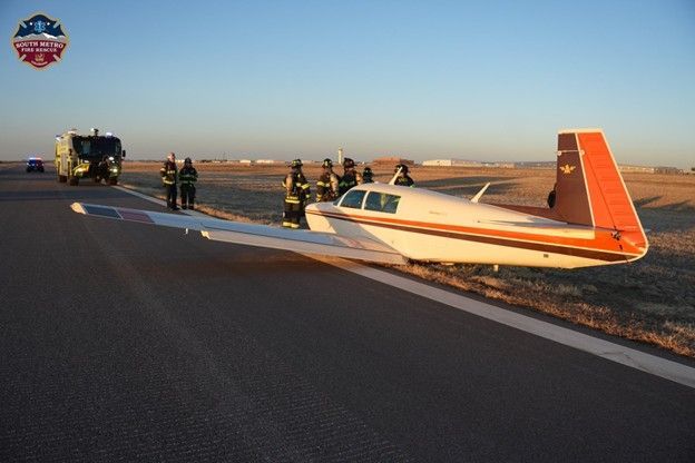
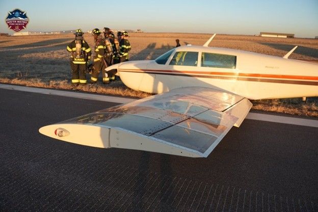
DENVER (KDVR) — A pilot is uninjured after landing off the runway without landing gear at the Centennial Airport on Thursday.
South Metro Fire Rescue reported the incident in a post on X just before 5 p.m. saying crews were responding to a reported aircraft emergency.
The Centennial Airport said it was alerted that a plane landed without landing gear beside Runway 35L at 4:44 p.m. A spokesperson for South Metro Fire Rescue told FOX31 that the airplane slid off the runway and ended up in the grass.
The airport said one person was inside the aircraft and was not injured.
SMFR said the aircraft was a single-engine Mooney 201.
https://kdvr.com/news/local/plane-without-gear-aircraft-emergency-centennial-airport/
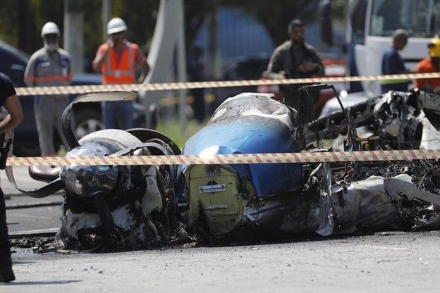
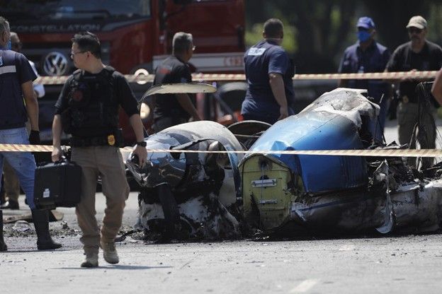
Plane crashes on avenue in Barra Funda, in the West Zone of São Paulo, leaving two dead and seven injured
Bus was hit by flames when the aircraft crashed, taking off from Campo de Marte towards Porto Alegre and crashing minutes later. 49-year-old lawyer and pilot were burned to death
Rafaela Gama, Hyndara Freitas and Matthew de Souza - Rio de Janeiro
A small plane crashed on Friday morning in Barra Funda, in the West Zone of São Paulo. The crash occurred near a bus on Avenida Marquês de São Vicente. According to the Fire Department, the accident left two dead and seven injured. The dead are the businessman and lawyer from Rio Grande do Sul, Márcio Louzada Carpena, 49, and the pilot Gustavo Medeiros .
The twin-engine plane is a King Air F90 model , with capacity for eight people, and took off with Carpena and the pilot in the morning from Campo de Marte Airport, in the North Zone. The airport reported that the control tower lost contact with the aircraft at 7:16 a.m., minutes after takeoff.
The two bodies were found charred inside the aircraft and, according to Firefighter Captain Ronaldo de Melo, one of them was in the front and the other in the back.
The aircraft belongs to the lawyer from Rio Grande do Sul, and was reportedly purchased on December 11th of last year . On Thursday morning, he posted a photo on Instagram stories announcing that he would be traveling from São Paulo to Porto Alegre .
The Fire Department reported that it has already completed the salvage work on the road, and now the area will remain isolated for expert investigation. The Aeronautical Accident Investigation and Prevention Center (Cenipa) will investigate the causes of the accident.
The crash site is close to the São Paulo training center, Allianz Parque, Memorial da América Latina, Museum of Brazilian Art and Football Museum.
Seven people with minor injuries were treated by rescue teams. Some of the injured on the ground were a woman who was inside the bus and a motorcyclist who was passing nearby. According to the Municipal Health Department, one woman was taken to the Municipal Emergency Room in Santana and is in stable condition. The motorcyclist was treated at the Barra Funda Emergency Room, suffered injuries to his arm and has already been discharged.
Viação Santa Brígida, the concessionaire responsible for the vehicle that was hit, reported that the bus driver had a sudden illness after helping to remove people from the bus, and was taken to a hospital shortly after, where he is receiving treatment. His health condition was not disclosed.
Although a bus was hit by the aircraft, the vehicle was not full because it was heading "to the neighborhood" and not to the more central region, according to Major Felipe Neves, spokesman for the Military Police of the State of São Paulo. Line 8500 had left the Barra Funda terminal and was heading towards Terminal Pirituba, in the Northwest Zone.
Firefighter Captain Ronaldo de Melo said at a press conference that the fire caused by the accident was “very aggressive ,” but the area is now safe. The most worrying case, he said, is that of a woman who was on the bus and hit her head.
— Inside the bus we had a lady who hit her head. In principle it is not very serious, but since she had this head injury it is always a precaution to make an observation in the hospital environment.
'Fireball'
The accident brought together onlookers, and most expressed concern because the accident had happened near a bus stop. Driver Giovani de Noronha was close to the scene when the plane crashed. According to him, the other bus driver involved in the accident tried to put out the flames, without success. Noronha said he arrived at the scene after seeing the smoke caused by the accident.
— He was in shock, he was taken away by ambulance — he said. — No one imagines a tragedy of this magnitude.
Elton Santos, a motorcyclist, was drinking coffee when the accident occurred in front of him. He says he was startled by the fireball.
— When it hit, the plane fell and started to catch fire. The people at the bus stop ran to the other side. The bus still came with the back of it on fire until it stopped.
Santos says he tried to help the motorcyclist who fell with a passenger due to the fright, but he said he was fine.
— I was drinking coffee. I was in shock.
Cenipa investigates
São Paulo's Secretary of Public Security, Guilherme Derrite, confirmed the information about the accident in a post on social media this morning. "Our teams are working on the crash of a twin-engine plane on Av. Marquês de São Vicente, in São Paulo. The Fire Department controlled the flames. Teams from the Military Police, Civil Police and Technical-Scientific Police are also supporting the incident," he wrote in the post.
Mayor Ricardo Nunes (MDB) also lamented the accident and stated that he made available "all assistance structures to help the victims", such as Civil Defense employees, SAMU, as well as traffic agents and the transport sector.
On social media, Governor Tarcísio de Freitas (Republicans) lamented the accident and highlighted "the rapid action of the Fire Department, which put out the flames of the accident in just a few minutes, preventing the tragedy from being even worse." "My condolences to the families and friends of the victims," he wrote.
In a statement, the Brazilian Air Force (FAB) said that investigators from the Fourth Regional Service for Investigation and Prevention of Aeronautical Accidents (SERIPA IV), a regional body of the Center for Investigation and Prevention of Aeronautical Accidents (CENIPA), located in São Paulo (SP), were called to the scene. "In the initial action, specific techniques are used, conducted by qualified and accredited personnel who collect and confirm data, preserve the elements, perform the initial verification of damage caused to the aircraft, or by the aircraft, and gather other information necessary for the investigation," the statement said.
Deviations on the route
Due to the accident, ten bus lines that pass through Avenida Marquês de São Vicente were diverted. According to SPTrans, buses coming from Ponte de Piqueri should take Viaduto da Lapa, and those coming from Marquês de São Vicente should take Avenida Pompeia or Ponte Júlio de Mesquita Neto. The following lines will be diverted until the accident site is cleared — which is not expected to happen, since the site is still being investigated:
- 129F/41 Connection Petrônio Portela - Post Office Square
- 209P/1 Cachoeirinha - Term. Pinheiros
- 209P/10 Cachoeirinha - Term. Pinheiros
- 8500/10 Term. Pirituba - Barra Funda Subway
- 8528/10 Guarani Garden - Post Office Square
- 8544/10 City of April 3rd Plot - Post Office Square
- 8600/10 Term. Pirituba - Lgo. do Paissandú
- 8600/22 Vl. Iório - Lgo. do Paissandú
- 9501/10 Term. Cachoeirinha - Lgo. do Paissandú
- 978A/10 Term. Cachoeirinha - Barra Funda Subway
https://oglobo.globo.com/brasil/noticia/2025/02/07/aviao-cai-em-avenida-na-zona-oeste-de-sao-paulo.ghtml
Crews searching open waters in Alaska for flight that went missing with 10 on board
By Jessie Yeung, Rebekah Riess and Isaac Yee, CNN
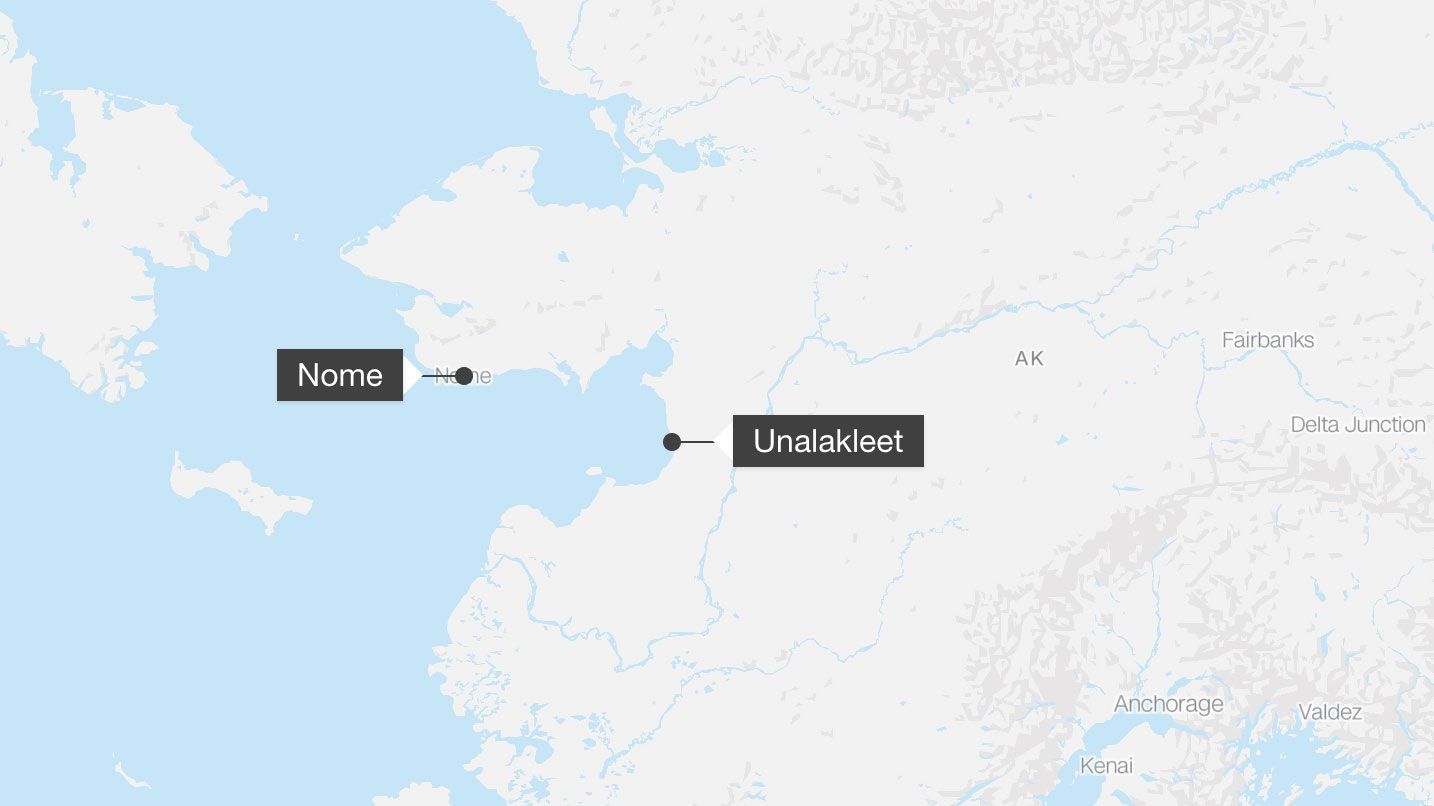
(CNN) A search of Alaskan waters is underway in rough weather after a regional airline flight with 10 people on board went missing, according to local and state officials.
The Cessna aircraft, operated by Bering Air, was en route Thursday from Unalakleet to Nome, cities in western Alaska separated by the Norton Sound inlet, according to the Alaska State Troopers. The state police agency was notified at 4 p.m. “an overdue aircraft” had gone missing with nine passengers and a pilot on board, it said in a news release.
The Nome Volunteer Fire Department was conducting ground searches from Nome and White Mountain but was limited in air searches due to poor weather and visibility, it said on Facebook. The US Coast Guard and US Air Force stepped in to help, with flights planned to scope out the area and try to locate the missing aircraft, the department said.
Bering Air is based in Nome and serves more than 30 local communities, according to its website.
The search comes as US air safety is under scrutiny as investigators probe two deadly incidents from last week: a January 29 midair collision of a US military Black Hawk helicopter and a passenger jet near Washington, DC, that left 67 people dead; and a January 31 crash of a medevac jet in Philadelphia that killed seven.
The plane missing in Alaska, a Cessna 208B Grand Caravan, was last seen over the Norton Sound around 3:16 p.m., data from flight tracker FlightRadar 24 shows. It was about 12 miles offshore when its position was lost, according to the Coast Guard.
The plane’s pilot had told air traffic control that he intended to enter a holding pattern while waiting for a runway to be cleared, the Nome Volunteer Fire Department said.
On Thursday evening, conditions around Nome Airport included light snow and freezing drizzle. At one point, visibility was down to half a mile, with forecasts of wind gusts up to 35 mph overnight.
“If that bad weather coated the wings with ice … the performance of the aircraft would degrade, and it could stall and crash,” CNN aviation analyst Miles O’Brien said Friday morning. “But there are places where the ice (in the sea below) is actually thick enough to support the craft, so that should give searchers some bit of hope.”
The fire department urged the public not to form their own search parties due to the weather and safety concerns.
The FBI is assisting the search with technical resources, including working to geolocate cell phones of the plane’s passengers, a bureau spokesperson told CNN. FBI field offices have personnel specially trained in analyzing cellular telephone tower data, which can assist authorities in geolocating the last registered location of a device.
The flight tracker also showed a Coast Guard HC-130 flying near the plane’s last known location on Thursday evening, with the fire department saying it carried “specialized equipment for search and rescue that enables them to locate objects and people through no visibility conditions.”
The National Guard and the Air Force each had a C-130 searching, also, but neither had reported seeing the missing craft as of 12:30 a.m. local time Friday, the fire department said.
“Staff at Bering Air is working hard to gather details, get emergency assistance, search and rescue going,” said David Olson, director of operations for Bering Air, the Associated Press reported. CNN has sought comment from Bering Air, which has been operating in Alaska since 1979.
Hospitals were gearing up in case they needed to respond, with the Norton Sound Health Corp. “standing ready to respond to a community medical emergency,” it said. The Norton Sound Regional Hospital also set up a family center for loved ones of the passengers to gather while waiting for news.
US Sen. Dan Sullivan of Alaska posted about the incident: “We are hearing reports of a possible missing plane en route to Nome. Our thoughts and prayers are with the passengers, their families and the rescue crew.”
CNN’s Robert Shackelford, Amanda Jackson, Josh Campbell, Jeremy Harlan and Martin Goillandeau contributed to this report.
https://edition.cnn.com/2025/02/07/us/alaska-cessna-bering-air-hnk/index.html
Jefferson County authorities search for plane crash, pilot located
by Payton Dhooge I Scott Solomon
PINE BLUFF, Ark. (KATV) — UPDATE 8:55 p.m.:
At about 7:02 p.m., the Metropolitan Emergency Communications Association was notified by the Federal Aviation Administration about a plane scheduled to land at the Grider Field Airport in Pine Bluff, two hours ago.
The administration reported that they had not heard from the pilot, according to a release.
MECA received a call at approximately 7:09 p.m., from a person who says he was the pilot of the plane that crashed.
The Arkansas State Police, Jefferson and Lincoln County Deputies joined in search for the pilot.
Other first responders were on the scene, as well as Grider Field Airport officials to join in.
Sheriff's Deputies from Lincoln County found the pilot and his plane at about 8:00 p.m.
The Jefferson County Sheriff's Office reports that the pilot appears to have sustained no serious injuries and that there were no other individuals inside the plane.
On the ground, no one was injured and no property as of now is considered damaged.
Original:
Emergency services in Jefferson County are actively searching for a small plane that may have crashed.
According to Deltaplex News, the pilot of the plane was found. It is not clear as of now if there were any more occupants inside.
https://katv.com/news/local/jefferson-county-authorities-search-for-possible-plane-crash-pilot-located-emergency-services-in-jefferson-county-are-actively-searching-for-a-small-plane-that-may-have-crashed

Swiss flight to Tel Aviv lands in Athens because of power bank
An Airbus A320 Neo belonging to the Swiss airline made an unscheduled landing in the Greek capital. There, the crew handed over a power bank to the fire department.
Timo Nowack
Since February 1st, Swiss has again operated the route between Zurich and Tel Aviv. On Thursday (February 6th), however, the Airbus A320 Neo used did not arrive in Israel as planned. The jet with the registration HB-JDH changed course over the Aegean and landed in Athens. However, the reason was not the security situation in Tel Aviv.
The reason was "a passenger's defective power bank," a Swiss spokeswoman explained. "The crew immediately stowed the device in the designated lithium safe bag - a special fireproof bag that is used to safely isolate potentially dangerous batteries." For safety reasons, the crew decided to land in Athens, where the power bank was handed over to the fire department.
Air Busan with new rules after fire
According to the Swiss Lufthansa subsidiary, there was never any danger to the passengers on board. Flight LX252 is now flying on to its actual destination, Tel Aviv.
Just this week, the Korean airline Air Busan announced that it would ban power banks in the luggage compartments above the seats . Travelers must keep the devices with them. Previously, an Airbus A321 belonging to the low-cost airline had burned out .
https://www.aerotelegraph.com/swiss-flug-nach-tel-aviv-landet-wegen-powerbank-in-athen

NTSB Final Report: Pool Cessna R172
Accident Flight Likely Encountered Moderate Mountain Wave Turbulence With Downdrafts As Strong As 500 Ft Per Minute
Location: Victor, Colorado Accident Number: CEN23FA174
Date & Time: May 6, 2023, 09:35 Local Registration: N15188
Aircraft: Pool Cessna R172 Aircraft Damage: Destroyed
Defining Event: Loss of control in flight Injuries: 4 Fatal
Flight Conducted Under: Part 91: General aviation - Personal
Analysis: After takeoff, the flight proceeded toward the intended destination airport. Position data initially depicted the airplane about 0.75 miles from the departure airport at 6,000 ft mean sea level. The final data point was recorded about 10 minutes later when the airplane was about 15 miles from the departure airport at an altitude of 9,400 ft msl. This was about 0.20 miles from the accident site.
The pilot’s family informed local authorities that the flight was overdue, and the accident site was located the following morning. The accident site was in mountainous terrain an elevation of about 9,170 ft. Terrain in the immediate vicinity of the accident site rose to nearly 9,300 ft. The airplane came to rest inverted after impacting trees and terrain. A postimpact fire consumed most of the fuselage. Postaccident examinations did not reveal any anomalies attributable to a preimpact failure or malfunction.
The accident flight likely encountered moderate mountain wave turbulence with downdrafts as strong as 500 ft per minute (fpm) and updrafts as strong as 1,000 fpm at the time of the accident. The weather conditions encountered were consistent with the National Weather Service G-AIRMET forecast. It is unknown what weather information the pilot received before or during the flight.
The expected climb performance at maximum gross weight and a pressure altitude of 10,000 ft was 450 fpm. This was about one-half of the expected climb rate at sea level. The estimated density altitude at the accident site was about 11,300 ft. Advisory information regarding mountain flying provided by the Federal Aviation Administration suggested maintaining at least 1,000 ft terrain clearance when navigating a mountain pass or crossing a ridge line. However, if the wind is above 20 knots, the suggested terrain clearance increased to 2,000 ft to avoid most of the turbulence and downdrafts.
As the airplane approached a mountain ridge line with about 100 ft altitude clearance, the pilot likely encountered previously forecasted moderate turbulence that exceeded the airplane’s climb capability at the elevated density altitude, resulting in an impact with trees and terrain.
Probable Cause and Findings: The National Transportation Safety Board determines the probable cause(s) of this accident to be -- The pilot’s failure to follow established mountain flying guidance, which resulted in a loss of control and impact with trees and mountainous terrain. Contributing to the accident was the airplane’s reduced climb performance at the elevated density altitude and the presence of moderate turbulence as forecasted.
FMI: www.ntsb.gov

Today in History
59 Years ago today: On 7 February 1966 An Indian Airlines, Fokker F-27 Friendship impacted a mountain in the Banihall Pass, India, killing all 37 occupants.
Date: Monday 7 February 1966
Time: 11:55
Type: Fokker F-27 Friendship 200
Owner/operator: Indian Airlines, lsf Schreiner Airways
Registration: PH-SAB
MSN: 10271
Year of manufacture: 1965
Total airframe hrs: 1930 hours
Cycles: 1280 flights
Fatalities: Fatalities: 37 / Occupants: 37
Other fatalities: 0
Aircraft damage: Destroyed, written off
Category: Accident
Location: Banihall Pass - India
Phase: En route
Nature: Passenger - Scheduled
Departure airport: Srinagar Airport (SXR/VISR)
Destination airport: Jammu-Satwari Airport (IXJ/VIJU)
Confidence Rating: Accident investigation report completed and information captured
Narrative:
An Indian Airlines, Fokker F-27 Friendship impacted a mountain in the Banihall Pass, India, killing all 37 occupants.
At 11:27 hours local time, the F-27 took off from Srinagar (SXR) for the return journey to Delhi-Palam Airport (DEL) with en route stops at Amritsar (ATQ) and Jammu (IXJ). The flight was cleared to climb VMC. A few seconds later, the Commander reported that he had climbed to 7500 ft and was turning to starboard. Srinagar Control requested a call while passing 8000 ft and the request was complied with. The controller then requested a call when passing 15 miles. No message, however, was received and at 11:40 controller asked for the position of the aircraft. The crew replied: "Will be crossing Banihal 2 to 3 minutes."
Erroneous navigation took the captain to a point 12 miles west of his normal route. At this spot, the configuration of the mountain range has a deceptive similarity with the Banihal Pass, and has, because of this similarity, come to be known as "False Banihal". The hills near "False Banihal" are several thousand feet higher than the true Banihal. The pilot must have realized his error and his wrong position too late when he saw the high mountain in front of him on emerging from the clouds. He attempted to climb but the aircraft hit the hill about 300 ft below the summit, at 12364 ft asl. It broke into two main pieces which fell on either side of a big rock, while several smaller pieces were broken off and scattered over a considerable area on the hillside. Some portions of the fuselage were found nearly 3000 ft below the point of impact.
PROBABLE CAUSE: "The cause of the accident was undoubtedly a navigational error. The Court was at first tempted to accept the hypothesis that the error was committed deliberately by Capt. Duggal because he wanted to take a short cut over the hill to Udampur, instead of going first to Banihal and then turning slightly right to the prescribed route to Udampur. Some support was lent to this hypothesis by the general assessment of Capt. Duggal's character as being hasty and casual and disinclined to pay heed to detail. But after giving greater consideration, it seems to the Court that this hypothesis cannot be accepted and that the navigational error was not intentional.
The configuration of the hill at a spot 12miles west of the Banihal Pass does not snow that the aircraft would have had a clear passage at an altitude of 12000ft because there are hills which are 14000ft high as shown by the contour lines on the map. Also Duggal did reply to the call 0610 hours GMT when he said that he would be crossing Banihal in two or three minted. It seems to the Court, therefore, that when flying through clouds at an altitude insufficient to ensure safety, Duggal found himself at a spot which resembled in its appearance the Banihal Pass. He must have steered an incorrect heading on leaving the airfield. Changes in cloud formation and decreasing visibility did not permit a full and clear view of the mountain range which lay across the route. So, when he was near the point where it crashed, he thought that he was going to cross Banihal and sent this message to the airport. In point of fact, he was 12 miles off his track and crashed at a point 12364ft above sea level.
A more careful and cautious pilot would, in the circumstances, have made sure of his direction and position by a reference to the Srinagar Airport where, in addition to the VOR, an Automatic Direction Finding facility is available."